

Climate Resilience Network
Scientists Serving Communities 2026
January 20-21, 2026
University of Maryland Campus
Scientists Serving Communities is the University of Maryland’s Climate Resilience Network’s yearly workshop designed to empower Maryland community leaders, stakeholders, and decision-makers. With no attendance fee, this workshop offers a unique platform to directly engage with University researchers and subject matter experts in an informal and impactful moderated discussion.
What to Expect
- Shape Research Priorities: Contribute to guiding the Climate Resilience Network’s research focus by sharing your needs and challenges as a community leader.
- Direct Communication: Communicate directly with scientists to ensure emerging research aligns with local climate resilience efforts.
- Collaborative Opportunities: Forge lasting partnerships that transform research into actionable projects, enhancing community resilience.
Sponsors

Conference Details
Click headings below to navigate through the details of Scientists Serving Communities 2026.
Schedule
Please note that this document is subject to change.
Select the name of the poster below and scroll below the list to view the poster information.
Title: Characterizing Maryland Shoreline Management Perceptions Using Q-Methodology
Presenter: Michael Wade, University of Maryland, 2025
Advisor: Dr. Parisa Rinaldi, St. Mary’s College of Maryland, Environmental Studies
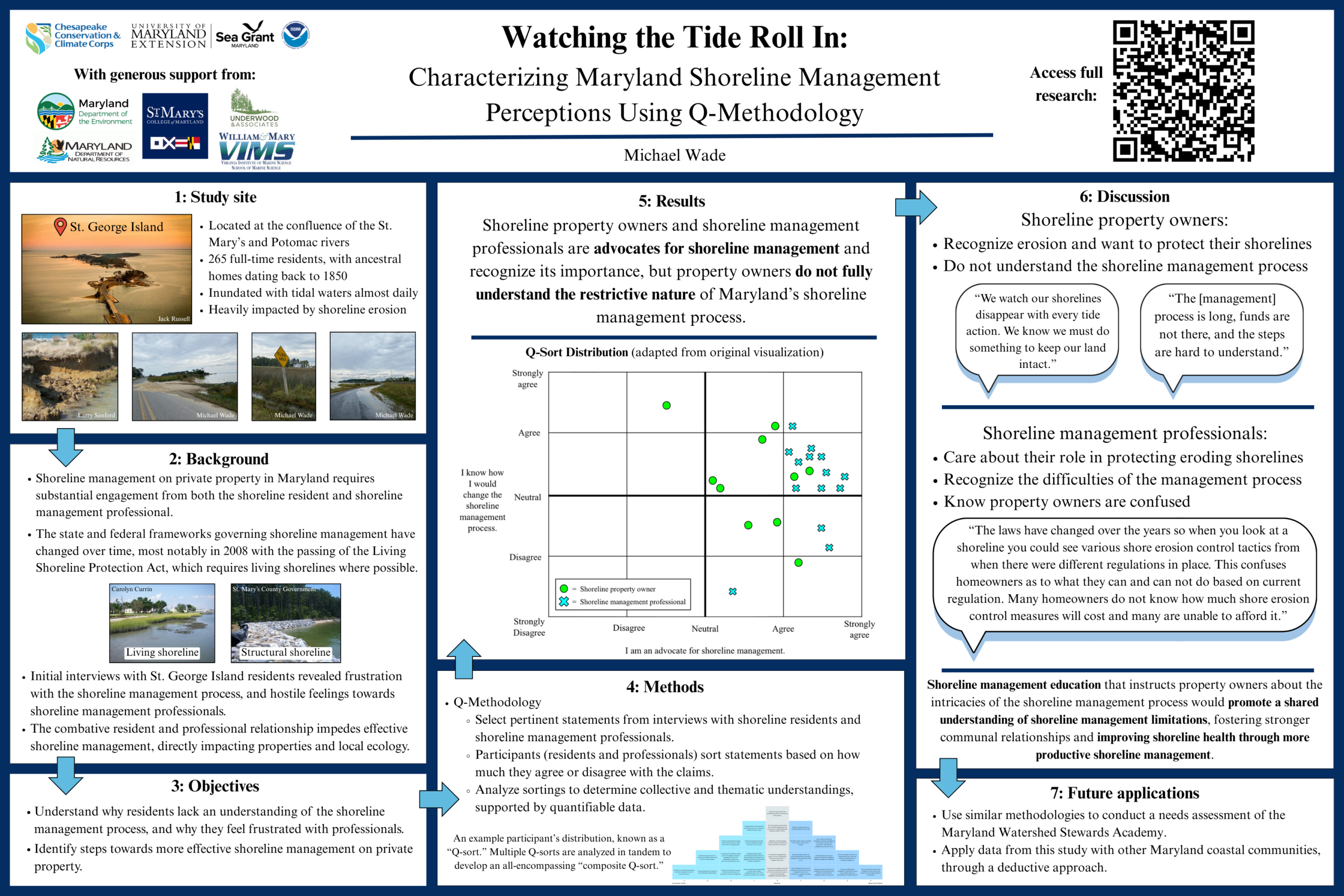
Maryland’s shoreline management process requires substantial cooperation between shoreline property owners and shoreline management professionals, but confusion regarding federal legislation and state shoreline regulations has driven a rift between these two communities. The shoreline management process in Maryland is guided by federal legislative frameworks that promote community participation within the shoreline management field. Existing research has thoroughly studied these frameworks as well as property owners’ and professionals’ roles within them but not compared these community perceptions with one another. This study examines the interrelationships between the perceptions of a Maryland coastal community and shoreline management professionals through Q-methodology, a social research method that identifies overarching perspectives from respondent data sets. Analyses show that property owners and professionals are advocates for shoreline management and recognize its importance, but property owners do not fully understand the restrictive nature of the shoreline management process. Professionals, working within regulations, frustrate property owners by limiting their management choices. Shoreline management education that informs property owners about the intricacies of the shoreline management process would promote a shared understanding of shoreline management limitations. Resolving this knowledge gap would greatly benefit both communities, prompting stronger communal relationships and improving shoreline health through more productive shoreline management.
Title: Comparing Piedmont and Coastal Plain near-surface substructures using p-wave refraction and surface wave dispersion
Present: Neha Narayan, Physics & Geophysics, University of Maryland, Expected May 2026
Advisor: Mong-Han Huang, University of Maryland, Geological Sciences
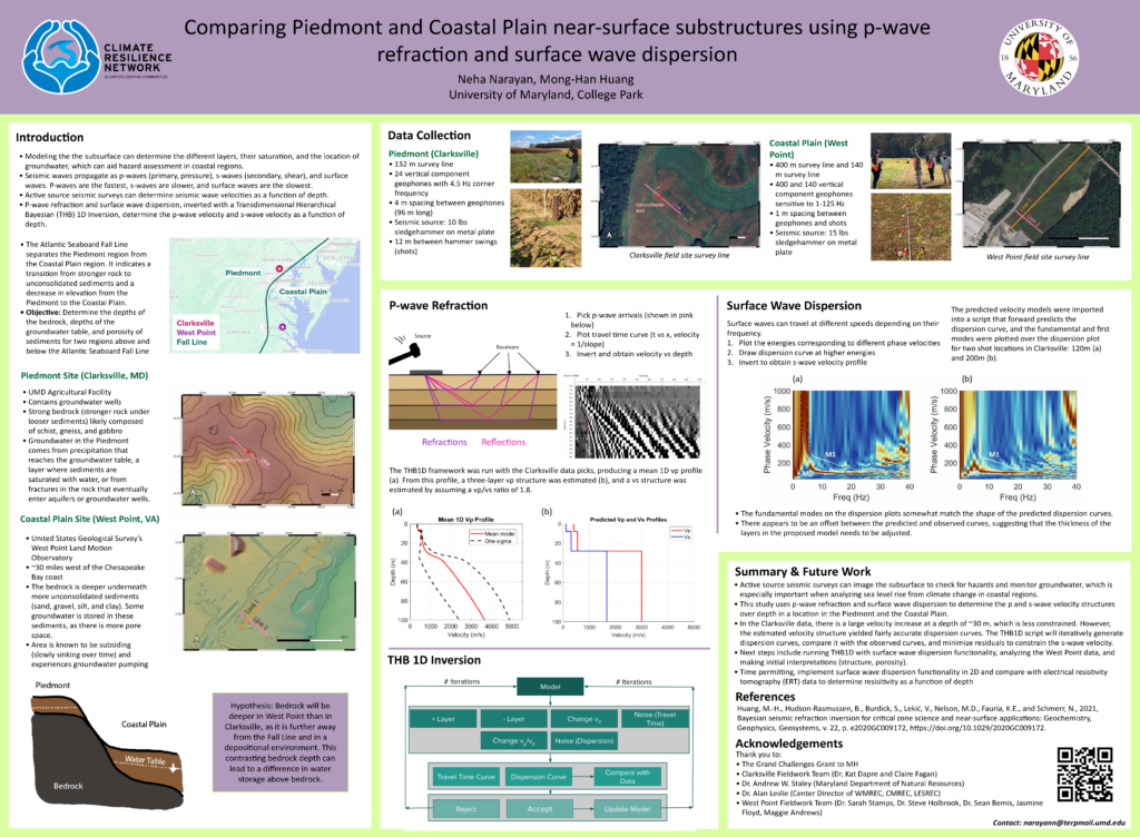
The near-surface substructure can inform how land can be used. Groundwater pumping, proximity to the coast, subsidence, and other hazards in the substructure may influence whether land is safe to use. This study utilizes near-surface geophysics to probe the subsurface in regions above and below the Atlantic Seaboard Fall Line to determine their material structures and level of saturation. The Fall Line indicates a transition from stronger rock to unconsolidated sediments and a decrease in elevation going from the Piedmont to the Coastal Plain, which indicates a possible contrast in substructure and subsurface water storage. A site in the Piedmont, a University of Maryland (UMD) Agricultural Facility in Clarksville, MD, and a site in the Coastal Plain, the United States Geological Survey’s West Point Land Motion Observatory in West Point, VA, were considered. The Clarksville location contains groundwater wells, and the West Point location is known to be subsiding. Active source data were collected, and the data were processed using a Transdimensional Hierarchical Bayesian frameworks (THB) that integrates p-wave refraction and surface wave dispersion to determine the seismic velocity structure over depth. These profiles will be analyzed to identify the depth of the bedrock and the depth of the groundwater table. This will also indicate saturation in the sediments, to help determine the porosity of the sediments. The p-wave velocity (vp) was constrained using a one-dimensional THB framework and a vp layered structure was estimated. The s-wave velocity was estimated using a vp/vs ratio of 1.8, and a script to forward predict a dispersion curve to implement into the THB framework was developed. The dispersion plots from Clarksville and the forward predicted dispersion curves somewhat agree, and the implementation of dispersion in the THB framework will minimize the disagreement.
Title: Design and Evaluation of a Low-Cost 3D-Printed Aspirated Radiation Shield for the Maryland Mesonet
Presenter: Katie Lehman
Advisor: James Hyde, University of Maryland, Maryland Mesonet; Tyler Boyle, National Institute of Standards and Technology
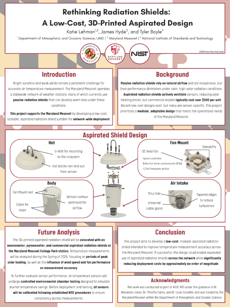
Accurate temperature measurements are essential for climate research, where long-term records support the study of variability, trends, and climate impacts. The Maryland Mesonet currently uses Metspec passive radiation shields, which are cost-effective but prone to warm biases under calm, sunny conditions. Aspirated radiation shields provide more reliable data, yet commercial models are disproportionately expensive, limiting their use in large-scale networks and making them inaccessible for educators and hobbyists. This project develops and evaluates a low-cost, 3D-printed, aspirated radiation shield designed to be scalable across multiple sensor types. Unlike prior designs optimized for single applications, this shield emphasizes adaptability, affordability, and accessibility. The goal is to reduce measurement bias within the Maryland Mesonet while also providing a replicable solution for community science and educational use. By leveraging additive manufacturing, the project expands access to high-quality climate instrumentation.
Title: Mapping Cacao Agroforestry with Multi-Sensor Remote Sensing in Diana, Madagascar.
Presenter: Monica Adjei, MS Geospatial Information Sciences, University of Maryland, 2026
Advisor: Dr. Catherine Nakalembe, University of Maryland, Geographical Sciences
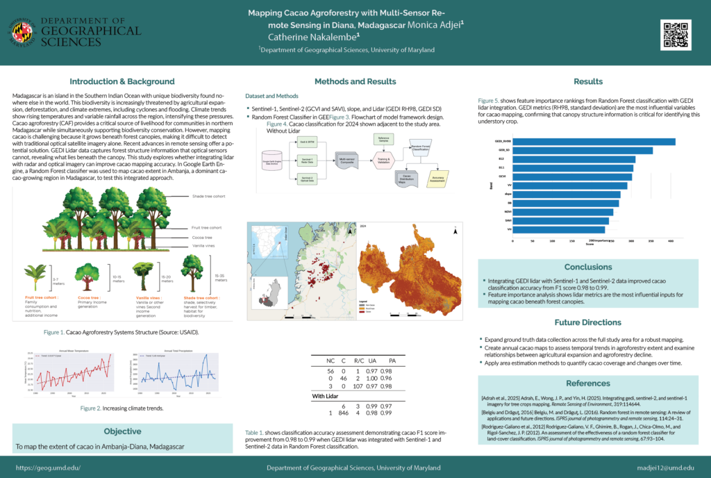
Madagascar faces escalating climate challenges, including rising temperatures, variable rainfall, and intensifying tropical cyclones that threaten both biodiversity and rural livelihoods. In northern Madagascar’s Diana Region, cacao agroforestry systems provide critical income for farming communities while supporting forest conservation and climate resilience. However, these systems are increasingly vulnerable to climate extremes, agricultural expansion, and deforestation. In addition, spatially explicit information on cacao distribution remains scarce, hindering efforts to support climate adaptation, monitor land use change, and target conservation resources effectively. This study demonstrates how integrated remote sensing technology can map climate- vulnerable agroforestry systems to support resilience planning and sustainable land management. The research combines optical imagery (Sentinel-2), radar data (Sentinel- 1), and lidar from NASA’s GEDI mission to overcome a critical challenge: cacao grows beneath forest canopies as an understory crop, making it invisible to traditional satellite monitoring. By integrating these multi-sensor data sources with machine learning (Random Forest classification), we successfully mapped cacao extent across the Ambanja region with high accuracy (F1-score: 0.99). Field-based reference data, including cacao plots, rice/crop areas, and non-cacao samples were used to train the classifier. Feature importance analysis revealed that lidar-derived canopy structure metrics were the most influential variables for accurate cacao detection, confirming that multi-sensor approaches are essential for mapping complex agroforestry landscapes. The resulting maps provide a spatially explicit view of cacao distribution in this climate-vulnerable region. These maps serve as decision-support tools for climate resilience and conservation planning. They enable the identification of biodiversity-rich agroforestry zones, monitoring of agricultural expansion patterns, and assessment of climate impacts on farming communities. As Madagascar experiences more frequent droughts and cyclones, understanding where vulnerable agroforestry systems are located becomes critical for targeting adaptation resources, supporting farmer resilience, and preserving forest ecosystems that provide natural flood mitigation. This research offers a scalable framework applicable to other climate-threatened agricultural systems worldwide, demonstrating how Earth observation technology can support communities adapting to climate change while protecting critical ecosystems.
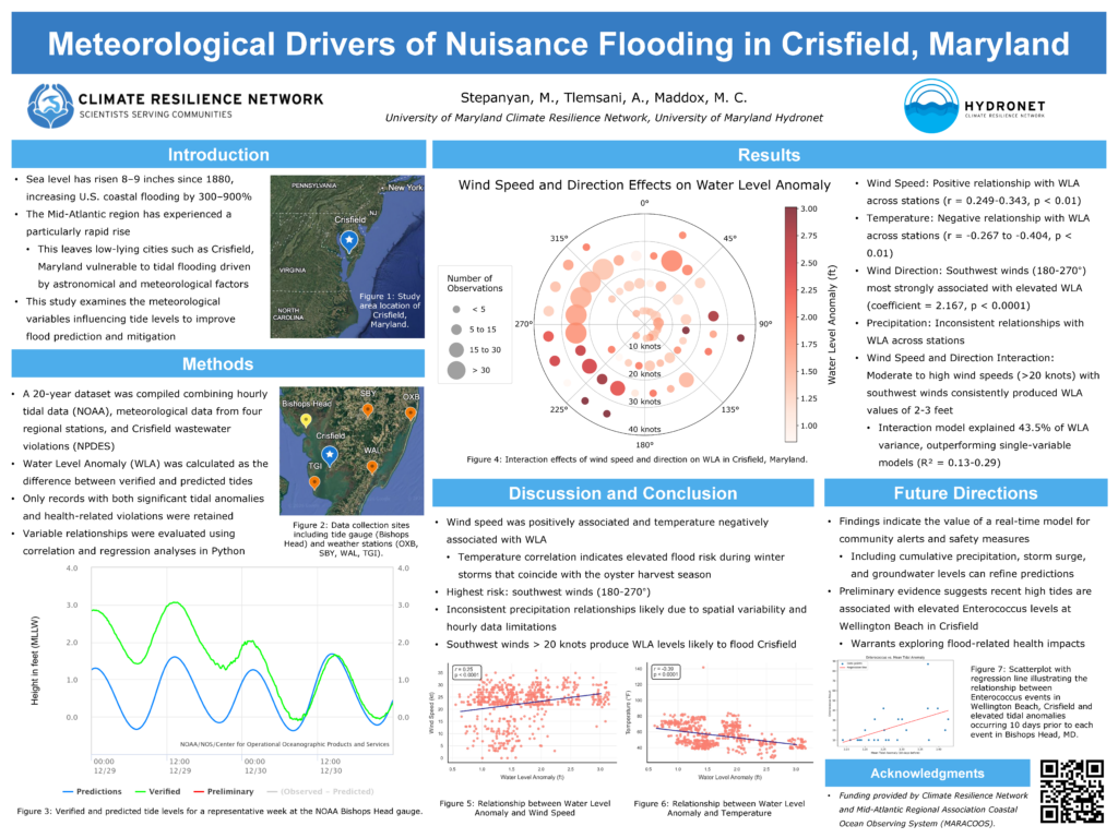
Title: Meteorological Drivers of Nuisance Flooding in Crisfield, Maryland
Presenter: Maria Stepanyan, Management and Public Health, University of Maryland, 2028
Advisor: Michael Maddox, University of Maryland, Climate Resilience Network
Nuisance, or “sunny day,” tidal flooding is increasing along the U.S. East Coast as sea-level rise combines with local environmental factors. Crisfield, Maryland, one of the region’s most vulnerable low-lying communities, regularly experiences flooding that disrupts infrastructure and contributes to wastewater overflows and bacterial contamination. This study examines how meteorological conditions influence tidal water level anomalies (WLAs) in Crisfield and how these anomalies relate to elevated enterococcus levels at a local beach. Using 20 years of tidal, weather, wastewater, and bacterial monitoring data, we conducted correlation and regression analyses to assess the impact of wind speed, wind direction, temperature, and precipitation on WLAs. Wind emerged as the strongest driver: winds from 180 to 270 degrees and speeds above 20 knots were most strongly associated with WLAs exceeding 2 or 3 feet, levels likely to trigger flooding. Temperature showed a consistent negative relationship with WLAs, while precipitation effects were inconsistent. Interaction models confirmed that specific wind speed and direction combinations significantly heighten flood risk. We also found that the 10-day average tidal anomaly prior to contamination events was moderately correlated with enterococcus levels (r = 0.550), suggesting that sustained elevated tides are linked to increased bacterial presence. These findings identify the meteorological conditions most strongly associated with nuisance flooding and related public health risks in Crisfield. They provide a foundation for developing predictive tools and early-warning systems to support resilience planning in coastal communities like Crisfield.
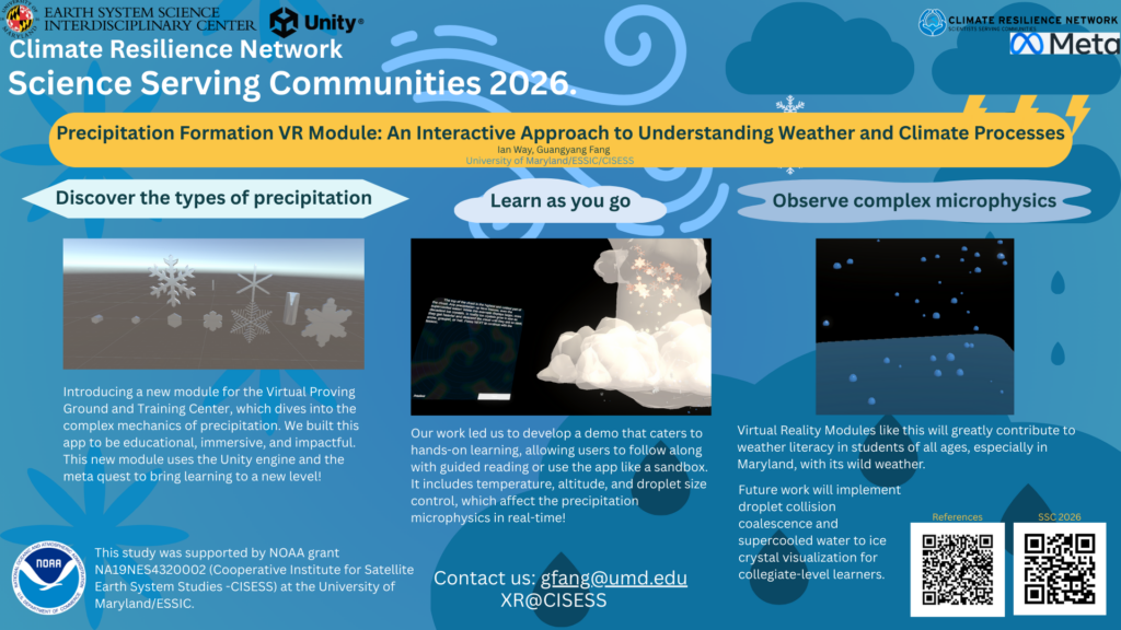
Title: Precipitation Formation VR Module: An Interactive Approach to Understanding Weather and Climate Processes
Presenter: Ian Way, Computer Science minor Business, University of Maryland, expected 2028
Advisor: Guangyang Fang, University of Maryland, Earth System Science Interdisciplinary Center (ESSIC)/Cooperative Institute for Satellite Earth System Studies (CISESS)
The Virtual Proving Ground and Training Center (VPGTC), developed at the Cooperative Institute for Satellite Earth System Studies (CISESS), is an immersive educational virtual-reality platform designed to help learners of all ages explore key atmospheric and climate processes. Because precipitation plays a central role in the water cycle, extreme weather, and climate, we created the Precipitation Formation Educational VR Module to visualize how precipitation forms and evolves under varying environmental conditions. The interactive module allows users to adjust factors such as temperature, altitude, and hydrometeor size to observe their impact on precipitation development. It also accurately simulates precipitation microphysics, including droplet deformation due to air resistance, precipitation phase changes, particle formation, and coalescence. By combining scientific accuracy with hands-on exploration, the module enhances understanding of precipitation dynamics – an essential component of weather and climate systems. In this presentation, I will discuss the design process, technical challenges, and educational potential of this VR tool within the broader VPGTC climate-education initiative.
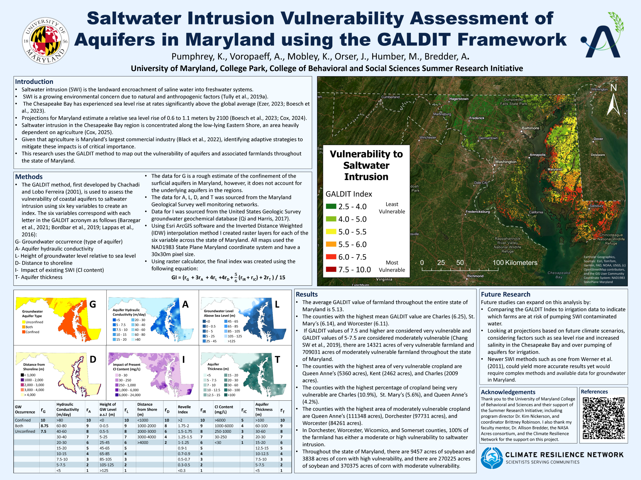
Title: Saltwater Intrusion Vulnerability Assessment of Aquifers in Maryland using the GALDIT Framework
Presenter: Kyle Pumphrey, Geospatial Data Science,University of Maryland, 2026
Advisor: Allison Bredder, University of Maryland, Geographical Sciences
Saltwater intrusion (SWI)—the landward encroachment of saline water into freshwater aquifers—poses an escalating threat in coastal regions due to the interplay of natural processes and human activities. In Maryland’s coastal plain, SWI is of particular concern, driven by accelerated sea-level rise and the region’s dependence on groundwater-irrigated agriculture. Salinization of agricultural soils alters biogeochemical properties, which can lead to diminished productivity and can ultimately render land unsuitable for cultivation. Given that agriculture constitutes Maryland’s largest commercial industry, understanding and mitigating SWI impacts is crucial. This study employs the GALDIT method to assess aquifer and farmland vulnerability to SWI across Maryland. GALDIT parameters include groundwater occurrence (aquifer type), aquifer hydraulic conductivity, groundwater level elevation relative to sea level, distance to shoreline, existing SWI impact (chloride content), and aquifer thickness. Utilizing data from the Maryland Geological Survey and U.S. Geological Survey, we integrated Geographic Information System (GIS) techniques—including inverse distance weighted interpolation, distance accumulation, raster calculations, and overlays with cropland areas to assess the vulnerability of every farm in Maryland to SWI. 720,000 acres of farmland, or over 60% of the total farmland across the state are vulnerable, including over 14,000 acres facing high risk of SWI. In several coastal counties including Dorchester, Worcester, Wicomico, and Somerset, every acre of farmland is at least moderately vulnerable to SWI. Key crops like corn and soybeans are under threat, with thousands of acres vulnerable to SWI. The resulting maps and data products provide a valuable tool for state, county, and farm-level planning and serve as a foundation for future research addressing SWI, sea-level rise, groundwater sustainability, and climate resilience in Maryland.
Contact
For questions and concerns about the conference, please click the link below to contact us.
Or contact climate-resilience@umd.edu